 Live Music Archive
 Librivox Free Audio
 Metropolitan Museum
 Cleveland Museum of Art
 Internet Arcade
 Console Living Room
 Books to Borrow
 Open Library
 TV News
 Understanding 9/11
tv Fox 5 Morning News Sunday FOX October 28, 2012 8:00am-9:00am EDT
8:00 am

. bracing for hurricane sandy. we have a lot coming up this morning. we're checking in with virginia and maryland emergency management, plus pepco joins us with how they are preparing for outages, and tips on how to make it through the coming storm. good morning. and welcome to fox 5 morning news sunday. first thing we want to do, of course this morning, what everybody wants to know, check in on the weather and you can see the wind picking up. the camera over crystal city, marine corps marathon this morning, and runners are out there in advance of the storm.
8:01 am
as we said, gwen, good morning. >> things will rapidly go downhill into this evening, melanie, and we want people to take this storm very seriously, because it is a massive storm. we are expecting massive winds and torrential rainfall. looking at the rain bands in the coastal area, sandy is moving in a northerly direction right now. even though it is still far away, we are feeling the effects. light rain in some areas, but to the south, heavier rain as the outer bands push their way towards the mid-atlantic. let's go to the maps and take a look at the spaghetti models, gradually coming together more and more, and this is very important, because it means that they are all kind of coming to a bit of consensus as to the fact
8:02 am
it is definitely going to take its turn heading to the northwest and where it's going to make landfall, is the key question, of course. that's still not exactly determined. we are looking at the track of it. right now, it's actually 395 miles east of charleston, south carolina. it will be off the virginia capes by early monday morning before it moves its way through and becomes a remnant low as it heads its way inland. once it's inland, still, we are talking a huge impact. even though it's not going to be a category 1 hurricane, the impact of the storm is going to be tremendous. the wind field is really huge and the torrential rainfall is going to be incredible, because it looks like it's really going start to slow down and possibly stall once it does move inland. that means extended periods of rainfall. here's a look at our wind field we've been talking about. we expect this to extend anywhere from 600 to even 700 miles up the coast, from the carolyn nas, all the way through to maine. the effects of this will definitely be felt.
8:03 am
wind gusts picking up to at least 60 miles an hour in some cases. so these damaging winds will definitely bring down trees and power lines and that's something that people really have to be aware of. extended periods of time, i'm sure, where there's going to be many, many power outages as a result of these winds. here's a look at future cast. let's look at the rain time line for us. it will gradually start to move in throughout the course of the day. this is at 1:00 this afternoon. when you start to see the yellow and the orange, that's really, really heavy rainfall. it's going to increase. here we are moving through into the 8:00 period tonight. there we aret 10:00 tonight. look at this, monday, 3:00 a.m., torrential rainfall. it's continuing right through the day on monday and as you take a look moving through, into the evening hours of monday, we're still in the thick of it. looks like cooler air is going to be moving across areas of the west, because we've got a frontal system there and that is setting up areas along the eang front, potomac highlands,
8:04 am

possibly seeing winter weather there. lot of things going on. the rainfall for our region could be anywhere from 6 to 8 inches or more. details a little bit later on and another update for you. melanie, back to you. >> thanks, gwen. we'll check back in with you. and people who are also braving out the storm in ocean city are already starting to see in outlying parts of the storm rolling in. we've got wind and heavy rain picking up there. it's expected later today. officials urge anyone who doesn't need to be there, to delay their visit until after the storm passes. in annapolis, people living near the coastline are being told to evacuate. there is a shelter at the annapolis high school. huntington high school in calvert county will also be opened as a shelter. if you go to a shelter, bring all of your medications and other essentials like clothes and toilet tries. the shelter will have food. you can bring pets, but be sure
8:05 am
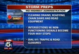
to bring their food and water bowls, as well as current vaccinations. if you have a smartphone, the red cross has an app that let's you enter your zip code and find the nearest open shelter. the maryland highway administration is also making sure people who have to travel can doit safely. crews are preparing by clearing drains, readying chainsaws and other equipment. the major concerns are significant tree damage and power outages and drivers, of course, are being reminded to treat those intersections with nonfunctioning traffic signals as four-way stops. the state highway administration will provide realtimeraffic information and road closures through the 511 phone system. well, it is time to make sure you are prepared for the storm. that is, of course, what everyone is going to be spending their sunday doing. before you head out, here's what you need to know. amtrak hans announced cancellations to some service and more cancellations likely. they urge ride stories check their website for the latest information. metro, so far, has not made any changes to service.
8:06 am

however that, could change when winds start to pick up. meantime, we started getting cal stations are already running out of gas. make sure you find a station that is open and fill up. and please be patient when standing in line. we've heard about some people getting a little irritable with other people already. we have much more on how local leaders and power companies are getting ready. coming up later, we'll speak with a representative from pepco, and rush earn baker, and the emergency management agency. and of course we'll check in with gwen throughout the hour for updates. you can get the latest updates 24/7 with the fox 5 weather app. i highly recommend it. it features live hd radar, weather alerts and more. you can also submit your weather pictures and video with the click of a button. download it on your ipad, iphone or droid. early voting got under way in several places in the district engineered and the lines were long. turnout was much bigger than
8:07 am

expected at the turkey thicket recreation center and there were only six voting machines working. lines were so long that some people actually gave up. in maryland, it was the same scene at the currie sports and learning center near fedex field. some people tell us they waited four hours to cast their vote. virginia, maryland and the district under a state of emergency this morning as we brace for sandy's landfall. officials are monitoring the storm at the operations center. first, we go to the director of maryland emergency management agency. ken, are you there for us this morning? >> yes, i'm here, melanie. >> grit. things are busy for you already, so i do appreciate your time this morning. tell us what you're doing right now to staff up. >> we are at what we call a level 1 full activation, 24/7 activation. all of our state agency partners, all our local partners are federal partners are here getting ready for prelandfall. >> and so, ken, where do you expect right now in maryland,
8:08 am

where the biggest impacts are going to be? >> this storm, melanie, is of historic proportions and we're going to see the issues from snow in western maryland to erosion and high storm surges in the last 25 years on the eastern shore, with high winds and with the stalling effect, all of maryland is going to be affected. specifically, any of those communities east of interstate 95, we'll see a potential significant flooding and surges and so all hands are on deck. all our county partners are ready to go. shelters are in lace. so now it's time to play ball. >> right, and so this is really -- today is sort of the day. if people haven't already made their preparations. what are you asking maryland residents to do today? >> what you could do today and what we've been saying over the
8:09 am

last week of tracking hurricane sandy, and today, there's not much you can do. if you can get some food commodities, fine. you should already have your batteries. you should have your personal documents in place. if you have outside furniture and things of that nature. you cure documents, insurance papers, licenses, have them with you, because once the storm goes through, you're going to need that information when working with your insurance carrier. >> and really, i don't know that you guys have ever dealt with a major winter storm and major coastal storm on either end of the state at the same time. how do you deal with that? >> well, we look at the planning and we are responding to incidents in an all-hazards perspective. it's the same type of response, just a different risk. so it's not unusual. we look at it from a wind event, from a high water event, snow event, and so we're ready and prepared to do that.
8:10 am

>> one of the questions that a lot of people have been asking at least over the weekend when i was at kids sports games and things like that, they wanted to know, when will we hear something about the schools? i know ultimately that is a school system call, but i'm assuming the school systems are in contact with your agency. >> they are in contact with their local emergency managers and each day we're going to be having another call at 9:00. most schools will make that call between 4:00 a.m. and 6:00 a.m. probably tomorrow morning there. so residents should listen. they normally get their robo calls to let them know whether school would be canceled. you'll hear that probably between 4:00 a.m. and 6:00 a.m. tomorrow. >> i've got it. thank you so much, ken. we appreciate it. >> thank you. and developing in the pacific, a very powerful 7.7 earthquake struck off the western coast of canada overnight. there were tsunami warnings issued for alaska and hawaii. in hawaii, evacuations were ordered along the coast.
8:11 am

just recently, it was downgraded a little while ago and only small waves are now hitting waikiki beach. there is still a tsunami advisory for northern california this morning. in northwest dc, metro says two buses were involved in a crash with a cadillac. metro says the car was being chase the by dc place. a metro spokesperson told us one hit at in graham street last night, then spun around and hit another bus traveling in the opposite direction. the buses did not hit each other. there were 10 passengers injured on those buses. none of the injuries are life threatening. and the bus drivers were not hurt. however, the man in the cadillac suffered leg injuries and was taken to howard university hospital. dc police say there was no chase, but that an npd sergeant witnessed the accident and tried to help on the scene. an investigation is continuing. well, runners are lacing up and pounding the pavement for this morning's 37th annual marine corps marathon. it is the fifth biggest marathon in the country and the 9th largest in the world.
8:12 am

we're going to take a live look right now at the start of the race in arlington. i can never find out how people aren't tripping all over each other at the race starts, because it is madness! a sea of people! it starts in arlington, ends at the iwo jima memorial. for one runner, this is a special race. sarah simmons has the inspiring story. >> reporter: life for army lieutenant cameron kerr changed in february 2011. >> when it first happened, first reaction was, oh, i think i stepped on an ied. then it sunk in, okay, this is what it's like, and this hurts. >> reporter: this picture with his platoon was taken less than a week from the day he stepped on an ied. he knew the dangers of war, but most, never imagined it happening to him. >> one day you're fighting, the next minute your parents are at your bedside and, yeah, it's weird. >> reporter: cameron is one of many soldiers who was sent to
8:13 am

walter reed for recovery. a prosthesis now takes the place of his left leg. >> but even for me, it's pretty simple. i get called a paper cut at walter reed, because this literally is a paper cut compared to others. >> reporter: an outdoorsman all his life, he became involved with inspirational organizations that keep him fit and challenged. he's become an avid runner. running the disney marathon with a sense of humor. >> i was the only adult tinker bell above the age of 4 1/2. >> reporter: he'll run the marine corps 10-k on sunday. >> they do give me that gentle nudge i need sometimes, the congratulatory hug at the finishing line, but right after that, the challenge of good job, but how would you like to do this? >> reporter: cameron will likely keep pushing his limits with this reminder in his head. >> there's always worse. there's never a reason to feel
8:14 am

sorry for yourself. >> and that was sarah simmons reporting again. here's another live look at the marine core marathon. the runners started just before 8:00. we'll bring you live updates throughout the show this morning. still ahead, a familiar face returns to the field today for the redskins game. everyone's looking forward to that. >> first, millions expected to lose power over the next few days. pepco will join us with more on how you can prepare and what it's plan is to tackle the widespread outage. we'll be back.


8:17 am

. utility crews expect millions to be left in the dark, as sandy comes ashore. companies are preparing for the outages to begin. take a look at your screen. i know you've got to squint a little there. you might want to write these numbers down, the numbers you need to know should your power go out. don't assume that someone living near you has reported the outage. you want to report your individual outage yourself. again, the numbers to call if
8:18 am

you lose power, especially you want to have the numbers handy, in case your cell phone no longer works. when the power outages begin and calls begin to pour it, in may take several days before power is restored. joining us now with insight on what to do when the power goes out and how crews are getting ready for the store, clay anderson with pepco. good morning, clay. i know you guys have started your 24-hour center already this morning. >> yes, we have. good morning, everyone. we've started in preparation for sandy about three or four days ago. we have our second rose, all of our men and women, 1500 pepco employees are now in their special storm response roles. we are waiting for the storm and it will be one we talk about, unfortunately for quite sometime. >> it's tough to say, clay. people are so sensitive to pepco, because they have been through this so many times before and then we get this letter from lawmakers basically wanting to know from pepco what are you doing now that's going
8:19 am

to make things better than before? >> i do understand what you're saying. first we want to tell your viewers and our customers that this storm sandy is not a pepco storm. this is an east coast major event. maryland, district of columbia, virginia, all under states of emergency. yes, pepco -- we have taken our lumps in the past, but we want our customers to know that we have been preparing, that the ratio came through an evening an overnight. sandy has been churning in the caribbean and atlantic for several days. we have called for over 2000 additional men and women to come in. we have already 600 already in place now, as far as our internal forces and our other tree crews, personnel, and we also have our contract crews that are at the ready. so we are prepared. we've been having meetings with government officials, so the government is definitely connected as far as in the
8:20 am

district. prince georges and montgomery county. we want to tell viewers that today is the last day to tie down everything that needs to be tied down, to get the things that you need, to get the water, to get the perishable items. because, yes, there will be outages. i'm going to say that again. yes, there will be outages. what's important is that this is a safety, an emergency situation. we want your viewers and our customers to be safe. we want our pepco employees to be safe. we have to make sure our families are safe before we go to work. we're doing that now so we can get the restoration effort started and get everybody back up as soon as we can. >> quickly, we have about 30 seconds left. what's the message you want to let people know about? what should they expect from pepco? expect the power to go out, then what should they expect in terms
8:21 am

of response from your crews and call centers? >> what they should expect is better communication from pepco. we will have our website updated, as all information is necessary. we'll be sending out information to the media in a timely manner. we'll be reaching out through our government officials in the area. we'll be working with government officials for emergency centers if they need to be. our number, 1-877-pepco-62. we have more operators that will be answering the phone to report downed wires. communication will be the key and we plan to do a much better job communicating with our customers as far as when their lights will come back on, when they go out. >> and that all starts this morning. clay anderson, thank you so much. also, hurricane sandy potentially impacting the campaign trail. plus, a swing state showdown this morning. we'll have a preview of what's coming up on fox news sunday and on the hill this week, when we come back. it's now 8:21.
8:22 am

anncr: which do you believe? what mitt romney's tv ads say about women? or what mitt romney himself says? mitt romney: do i believe the supreme court... should overturn roe v. wade? yes. and it would be my preference that they, that they... reverse roe v. wade. hopefully reverse roe v. wade. overturn roe v. wade. planned parenthood, we're going to get rid of that. i'll cut off funding to planned parenthood. anncr: no matter what mitt romney's ads say. we know what he'll do. president obama: i'm barack obama and... i approve this message.


8:25 am

. the presidential candidates postponing campaigning because of the storm. barack obama planning to skip events tomorrow and tuesday to monitor the situation from the white house. he and mitt romney are both canceling appearances in virginia. romney is instead campaigning today in ohio. with a little more than a week to go before the presidential election, it is down to the wire in the crucial swing states and the polls are tightening up. with that in mind, fox news sunday is hosting a swing state showdown this morning. senators from wisconsin, colorado, ohio, and virginia will discuss the all-important ground game in their states, as well as the economy and developments in libya. virginia senator mark warner will be on the show supporting president obama. he'll also talk about the contest between tim kaine and george allen. that's coming up at 9:00, right after fox 5 morning news. . it's your look at the new and noteworthy in the week ahead. it is the capital rundown for
8:26 am

the week of october 29th, 2012. on monday at 9:30 a.m., the united states supreme court hears arguments in the case of james clapper versus amnesty international. the case looks at the constitutionality of federal wiretapping laws. tuesday, october 30th at 11:00 a.m., the national press club hosts democratic campaign chairman congressman steve israel of new york and republican policy chairman congressman tom christ of georgia. they will speak about the status of the upcoming congressional elections. wednesday, october 31st at 10:00 a.m., the ceo of nastc speaks at the birthing in stewings on why the markets are still on the sidelines in this recovery and how a stable federal budget could change that. a new month starts thursday, november 1st, and at 4:00 p.m. at the library of congress, they will host a lecture by historian john witty, jr. on the spread of muslim law and what place faith-based laws have in western
8:27 am

democracy. friday, on friday, november 2nd at 7:30 p.m., celebrating its 50th anniversary, the uso is handling its annual gala at the washington hilton, honoring the men and women of the u.s. military. jordan sparks will perform and fox 5's allison seymour will serve as emcee. that's your capital rundown for your week of october 29th, 2012. keep checking myfoxdc.com for more and our twitter hashtag for more. i'm tom fitzgerald. see you next week. up next, we'll check in with virginia emergency management and how they are preparing for effects in the commonwealth. plus, more on how you can weather the storm. stay with us. a lot more storm coverage, coming your way right after the break. employees insurance company, or geico...as most of you know it. ...i propose savings for everyone!
8:28 am

i'm talking hundreds here... and furthermore.. newcaster: breaking news. the gecko is demanding free pudding. and political parties that are actual parties! with cake! and presents! ah, that was good. too bad nobody could hear me. geico. fifteen minutes could save you fifteen percent or more on car insurance. prand you're seeing that rightno quit in amnow.a... over five million new jobs. exports up forty one percent. home values... rising. our auto industry... back. and our heroes are coming home.
8:29 am

we're not there yet, but we've made real progress and the... last thing we should do is turn back now. here's my plan for the next four years: making education and training a national priority; building on our manufacturing boom; boosting american-made energy; reducing the deficits responsibly by cutting where... we can, and asking the wealthy to pay a little more. and ending the war in afghanistan, so we can... do some nation-building here at home. that's the right path. so read my plan, compare it to governor romney's... and decide which is better for you. it's an honor to be your president... and i'm asking for your vote... so together, we can keep moving america forward. i'm barack obama and i approve this message.

8:31 am
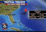
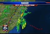
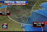
everyone's mind is sandy. gwen, you and the fox 5 weather center are going to be here throughout the storm. >> that's right. >> and the updates keep coming. >> they do keep coming. let's take a look now at radar. you'll see where the bands of rain are affecting areas of the coast. some of that heavier rainfall to the south of dc, but it gradually starts to move its way in through the course of the day and we'll really see our conditions go downhill. let's go to weather maps and take a look at a track of sandy. sandy is currently 395 miles east of charleston, south carolina, expecting to take a north, then northwesterly turn heading towards the mid-atlantic and starts to move in. we are looking at heavy rainfall that's going to be spread with this as well. take a look at that cone that you see there. that's called the cone of uncertainty. anywhere we see that is where we're looking at that making landfall, and that's a question until it heads up north. this is a very powerful storm. here's a look at the wind gusts
8:32 am
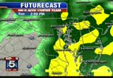
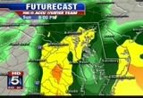
we're anticipating. by monday at 5:00, wind gusts up to 50, 59 miles per hour, as well as into the 60s. look at this. monday, 11:00 at night, we're talking 65 mile-per-hour wind gusts here. by tuesday, they are still into the 50s pretty much everywhere. by noon tuesday, they start to die down a little bit and we start to see improvement the closer we get into wednesday. the wind field is going to be enormous, stretching anywhere from 6 to 700 miles up the mid-atlantic. here's future cast for you. rain will start to move in this afternoon. by 2:00, you can see where we go here. once we get into the orange and yellow, it gets even heavier. we're talking torrential amounts of rainfall for our entire area. this lasting all through sunday, monday, into tuesday. we have this long, extended period of rainfall that's even going to be sticking around a bit in the early part of wednesday. on the back side, cooler air moves into the west and we're talking snow across the allegheny front and as well through the potomac highlands.
8:33 am

very dangerous storm situation here. it is expected to be worse than irene was. please, i'm going to beg our viewers, take this very seriously. >> all right, again, keep updating throughout the day and throughout the week, gwen. thank you very much. well, also, virginia on the mind of many folks. flooding is expected in many parts there. we go to the phone to governor bob macdonald. thank you for joining us, governor. >> thanks, melanie. appreciate you having us on so we can talk to the viewers about getting ready for the storm. >> and so what are you bracing for in virginia right now? >> well, the biggest threats are the sustained, sustained combination of wind, rain that causes downed power lines. we're expecting sustained winds of 50, 60 mile-an-hour near the coast with 8 to 10 inches of rain. and you do that from sunday to wednesday and you're looking at downed trees and power outages. and that's our biggest concern.
8:34 am

then follow that by cold as opposed to the heat we've had with other hurricanes. we just want to have people be prepared, take all the precautions, be a good neighbor and stay off the roads during the peak of the storm. >> and so you have declared a state of emergency. again, we talked about this a little bit. i'm going ask the county executive here, lot of people are concerned about schools and what that's going to mean for schools. >> well, the state of emergency helps us, which i declared friday morning, helps us to be prepared. state police, national guard, open emergency operation centers, give authority to declare mandatory evacuations t helps tremendously with the cooperation between state, local and federal government. we've now got the fema teams on the ground today and i think we're ready. schools will be a day-by-day
8:35 am

call and largely up to the local government to determine whether it's safe to have buses and kids out on the road over the next two days. >> and i got to ask you, another thing that's sort of been bubbling up here, and i know we're way ahead of it, it's a long shot, but some people had power out for more than a week. what happens if power is out november 6th? >> well, we have contingency plans in place right now. we've already worked with dominion power to make sure that polling places and registrar's offices are among the highest priorities for power restoration. we anticipate having a full seven days before the election to have power restored. so we don't anticipate that being a problem at all. if people are inconvenienced right now because they can't get to a registrar's office to do absentee voting, we're looking at possibly extending hours before the election to make sure
8:36 am

that happens. that is clearly on our mind. the state board of elections is doing everything that they can to minimize inconvenience to voters. but we don't anticipate a problem on election day right now. >> let's keep our fingers crossed that that is not going to happen and that everyone gets through this safe and sound. governor, thank you for joining us this morning. >> glad to be on. thank you. and we'll be right back, of course. first, let's take a live picture of route 50 at the draw bridge in ocean city. you can see the rain coming down right now, cameras shaking a bit, winds picking up. update on sandy's track, which we come back. ♪

8:38 am

♪ [ male announcer ] combine the pnc cashbuilder visa credit card with a qualifying pnc performance select checking account and earn 75% more than cards earning 1% cash back on almost everything. earning 1% cash back we had a good d group of people. good group of employees out there. this was a booming place. and mitt romney and bain capital turned it in to a junk yard. i was suddenly, 60 years old. i had no health care.
8:39 am

mainly i was thinking about my family. how am i going to take care of my family. he promised us the same things he's promising the united states. and he'll give you the same thing he gave us. nothing. anncr: priorities usa action is responsible for the content of this advertising. . well, hurricane sandy could cut off power to thousands in virginia. we'll get more now on preparations in the commonwealth. joining me on the phone is the director of public affairs for emergency management, bob spill. good morning, bob. >> good morning, melanie. >> i'm assuming you have your emergency operations center up and running now, like many others. >> yes. the state emergency operation center has been up and running
8:40 am

for a couple of days now. we have much more staff in here today from various state agencies, fema, coastguard, military units. so we have a lot of folks in the emergency operations center ready to help out the local governments. >> and what is everyone doing in there? we talk so much about emergency operations center, but are you guys having regular briefings, figuring out how you'll get information out to the public? >> yeah, we do a lot of the information gathering and putting out information, but our main thing is to support the local officials responding directly to the disaster. so what we look at is what kind of resources we have at the state level, whether it's personnel like vdot, department of transportation, state police, national guard, resources that might be able to help out and support the local officials. >> and what are you anticipating right now in terms of needing additional help? do you feel like there's going to be enough already? >> yeah, i think in the state we feel pretty confident with resources that we have. we're fairly experienced at these type of events.
8:41 am

unfortunately. so we have a pretty good game plan in place. we've got national guard, state police, department of transportation personnel prestaged, ready to go in some of the key areas. so we'll just have to wait and see what sandy's going to bring us. >> all right, and what are you asking people, what should they expect from emergency operations? should they be -- where can they go to get the best updated information? >> the best information is to always go to their local news and local officials, where they are going to get the best information about specific information that they need to know about, and then they can also go to vaemergency.gov. we'll have information there throughout the event. but always, their local officials, local websites and local media are the best place to go to. >> great, and how beneficial is it to you that we've been talking about this coming storm for at least five, six days now? >> yeah, we've had a lot of warning with sandy. so it's important for people to take, always to take it
8:42 am

seriously and to be ready and be prepared. you never know what these storms are going to bring. flooding, heavy rain, power outages. so you just need to be ready with it, have your emergency supplies. we still have a little bit of time, especially up in the northern virginia area, for folks to get those supplies that they might need and to have everything ready to go before this real brunt of the storm hits. >> bob, thanks again for joining us this morning. we know you're busy and we do appreciate your time. >> thank you. i'll sit down with prince george's county executives. gwen? things are calm right now, but we are on a downhill trend into the course of the afternoon. sandy is not far away and will be making a huge impact on our area. we're talking torrential rain, lots of flooding, strong winds, power outages and downed trees. i'll have details and an update, coming up. stay with us. we'll be back after the break. anncr: their ads, hopelessly untrtrue.


8:45 am

a west virginia casino launching the biggest ad barrage ever. don't be misled. the washington post says question seven is just... common sense. it'll create 4,000 permanent jobs. and stop maryland from losing millions to other states... every year. that's why business, labor, and teachers all support... question seven. and so does the washington post. vote for question seven. it's just common sense.
8:46 am

. and welcome back to fox 5 morning news sunday. 8:45 now. gwen toll bart is back with the latest. >> we'll give you a complete update on sandy and what to expect and the timing. once again, a very dangerous storm we're facing, so let's get right to it. taking a live look outside first, things are a lot calmer this morning across our area. we're seeing a few clouds and some of you may be seeing a few sprinkles as we start out. but that is definitely going to change as the day progresses and as we get into the evening hours, things are really going to start to go downhill quite a bit. so we really want you to be prepared for this, because we're getting plenty of warning of what is to come. let's begin with a look at radar. here's a look at the rain bands from sandy, already starting to push their way up into the mid-atlantic here, some of this heavier. we are starting, as i said, to see a few sprinkles here and there. this will all push its way to the west very quickly into the course of this afternoon and later on this evening. let's go to our weather maps.
8:47 am

our spaghetti models coming together a little bit better now and so we're getting a little bit more of a consensus on things. take a look. the majority of them all kind of agreeing on where this will pull itself together. this is really crucial. we're still looking for a little bit more consensus on these spaghetti models, but so far have pretty much been on track in terms of where the projected track seems to be taking it. here's a look at where that is. the storm is currently 395 miles to the south of charleston, south carolina, and it actually has sustained winds now of 75 miles per hour. so still a category 1 hurricane. if you take a look here, anticipating it making landfall at some point on monday. it will become a remnant low as it moves inland. now, this is a problem. here's what's going on. looks like it's going to move in very, very slowly. looks like there's a chance it will stall once it does hit into parts of north central maryland and into pennsylvania. that's not a good thing, because once it stalls, it will just sit
8:48 am

there and we get more rain and more rain and we're talking torrential rainfall. but look at this cone here of uncertainty. this is huge, because this is also going to be an expansion of where we expect the wind field to be and that wind field is expected to stretch anywhere from the carolinas all the way straight up to maine. some 600 to 700 miles. these winds are going to be gusty, gale force winds as well, gusts that will reach up to 60-plus miles per hour across this area. and that also encompasses the washington, dc, maryland, virginia areas as well, for our viewing region. so those winds, very dangerous. we're talking about a wide path, swath of winds here that are going to be even more dangerous than hurricane irene was. so you really have to take this seriously. here's a look at projected wind gusts. tonight, we're talking about 20 to 25 mile-per-hour range. but look at this on monday by 5:00. gales and wind gusts up to 53 miles per hour, increasing to the mid-60s bit time we get into
8:49 am

monday night, into tuesday. once again, 50 mile-per-hour wind gusts, only dying down once we get into the early morning hours of wednesday. right now, we've got tropical storm warnings along the north carolina coastal region. i do anticipate to see those increasing later today. future cast showing you, look at this, 2:00 this afternoon, we're already into copious amounts of rainfall here. it just increases in the overnight hours, torrential rain continuing sunday all the way through into monday, all the way through into tuesday. this is really, really heavy rainfall here. then on the back side of it to the west, we're looking at it interacting with another system, cooler air pushing in, a little more energy for it, and that's going to end up leaving us with a little bit of snow possibly across our mountains. so expect to see through the dc area and south, 6 to 8 inches of rainfall, 4 to 6 to the north of us. very dangerous storm. melanie? >> thank you, gwen. don't forget, you can get instant weather updates with the fox 5 weather app, track sandy as the storm approaches, and submit your weather pictures.
8:50 am

the app is available in the apple store and android market. prince george's county executive baker joins us now to talk about local preparations. and i have to say you and i kind of both went, oh, when we talk about maryland. >> i love gwen, but she just depresses me! >> with the possibility of flooding and storm surge on one side of the state and snow on the other side of the state, i mean, what is going on? >> oh, well, the good thing i can say to residents of prince george's county is that we've been preparing for this since we were first notified. so our offices have been meeting, all the county offices, last week preparing for sandy to come. our emergency preparedness office is going to open this morning at 10:00. everyone knows the governor's already declared a state of emergency. and there's a couple of things we want people to remember. you can sign up for notify me, which will give you up-to-date information about the storm and what's going o.
8:51 am

>> that would be on a smartphone. >> smartphone, going to prince george's county.gov. and that will give you updated information on what's going on. >> and twitter's a good place to follow you. >> yes, it is. >> i've asked a couple of people about this. parents are worried about school, worried about why we are waiting until 4:00 to 6:00 in the morning. i know it's not your call. >> one of the things we've learned from the last couple of natural disasters is to coordinate with schools. we'll get the information out quicker. the school system will do it, but coordinate with the government. because of the roads, we control the roads that are going back and forth, and so we want to make sure we're coordinated. i just had my last child graduate from high school, so i know what it's like to be in that position. so we want to make sure we get
8:52 am

it out as soon as possible. >> and you know, i think another thing, we've been talking about this for so many days. it does cause a certain amount of anxiety among people. i'm sure you heard that from some of your staff and also from residents. what would you tell people about, you know, we'll get through it? >> one of the things is we've learned. we've learned from the last couple of natural disasters that's happened in this area. we are prepared for it as best we can be. we know when we need to open up shelters in case power goes out for an extended period of time. we are staffing up. we've got some tools in place now in prince george's county we didn't have before. our 311 system is there, so you can call for nonemergency calls. county click, which you can download to your iphone and there's an app for that to get you updated information. so we're prepared as best. you see pepco and other power companies out there early, anticipation. >> we're hoping it works this time. and finally, i asked the governor about this and i know
8:53 am

we're way far out, but the election certainly is on people's minds. we did have power outages with the draich yo that lasted for a week. he told me they are trying to get polling places to be first priority getting power back on. are you looking at that now? very important questions on the ballot. >> and early voting starting this weekend. our elections office are coordinating with them to make sure we are prepared as best as possible, so the people can go out and vote. the good thing, people started voting really early on saturday. there were long lines, anticipating it. >> we saw that, yeah. >> we're asking people to make sure they do that. and we'll do everything we can to make that a priority. >> can people go out and vote today if they want to? i don't think it's open on sunday. >> it's not open on sunday. >> all right. >> but we will coordinate with their office to make sure it's a priority. >> lots to think about, lots to work on. thank you very much, county executive baker for taking the time this morning. when thousands of runners
8:54 am

hitting the pavement at the marine corps marathon. we'll be back to talk more about that in just a minute. [ earnest ] out of the blue one day, we were told to build a 30-foot stage. gathered the guys and we built that 30-foot stage, not knowing what it was for. just days later, all three shifts were told to assemble in the warehouse. a group of people walked out on that stage and told us that the plant is now closed and all of you are fired... i looked both ways, i looked at the crowd, and...we all just lost our jobs. we don't have an income. mitt romney made over 100 million dollars by shutting down our plant and devastated our lives. turns out that when we built that stage,
8:55 am

it was like building my own coffin, and it just made me sick. [ male announcer ] priorities usa action is responsible for the content of this advertising.
8:56 am

. and we are taking another look right now at the marine corps marathon. lots of people out there running this morning, in anticipation of the storm, i suppose, getting it in there! they worked so hard for this all
8:57 am

year long. a little bit of sprinkles on them as well, keeping them cool. not too much heat that they are dealing with this morning, right, gwen? >> right. they are getting out there early. high-five to the marines out there. that is awesome, absolutely awesome. well, the weather will definitely take a downhill turn later on. >> absolutely. big day for burgandy and gold as well, another great thing to do to keep your mind off the storm. 11:00 to 1:30, game time, redskins pregame and kickoff at 1:00. we'll see how much playing time chris cooley gets, the return of capital chaos. and the giants at dallas. tonight at 8:00, game 4 of the world series, as the giants are in detroit. then stay tuned to fox 5 for complete coverage of hurricane sandy, here on fox 5. gwen, lots of stuff going on today, again, so the people can kind of put their mind on other things, but also do need to keep
8:58 am
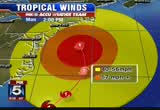
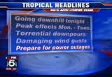
paying attention to what will be coming this way. >> definitely. by the time we get closer to 1:00 to 2:00, we'll see heavier rainfall coming. >> 1:00 to 2:00 this afternoon? >> yeah. get out and do what you need to early today and be safe. let's take a look. here's a look at the wind field. this is a huge thing, because those winds are going to be gusting up to 60 miles an hour in some cases, anywhere from the 50 to 60 mile-per-hour wind gust by the time we get into the monday-tuesday period. it will start to pick up again as well tonight. huge wind field is going to expand anywhere from 600 to 700 miles all the way up the coast. strong winds, downed trees and power lines a major, major issue. we're also talking plenty of rainfall as well, torrential rain that's going to start in the course of today, folks. be prepared. 6 to 8 inches dc to the east and south, 4 to 6 areas to the north and west. flood watch tonight through tuesday evening. high wind warning monday night to tuesday evening. coastal flood watch monday night
8:59 am
to tuesday evening. and coastal flood advisory until midnight on monday. we are tracking this very closely. it starts to go downhill tonight. peak effect will be monday to tuesday. torrential downpours expected, damaging wind gusts as well. you need to prepare for power outages. this storm is going to be stronger than irene was. it's much bigger. it's a massive, massive storm. and this is why we really have to take it very seriously. we're talking flooding already along ocean city, the levels of the water are already a foot and a half higher than they usually are. so that's something that's another issue. >> and we want to remind people, we've put those numbers up on the screen again. again, up to the write these down, because if there are extended power outages, you'll lose battery on your cell phone. there's still a little bit of time for people to get out there. >> that's right. get out there before noon is my suggestion to you. do what you need to do, get batteries, get to the atm machines. >> good idea. >> thanks so m
236 Views
IN COLLECTIONS
WTTG (FOX) Television Archive
  Television Archive News Search Service
Uploaded by TV Archive on
